(Cuyahoga River Community Planning)
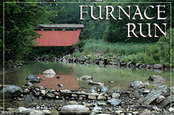
FURNACE RUN
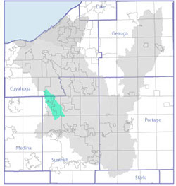
drains 20 miles in western Summit County and a small portion of Cuyahoga County, including the communities of Brecksville, Broadview Heights, the Village of Richfield, Richfield Township, Bath Township and Boston Township.
It is straight and steep and its many streams send volumes of sediment into the Cuyahoga as it finishes its run through Metroparks, Serving Summit County and Cuyahoga Valley National Park.
Its covered bridge is a favorite hiking destination.
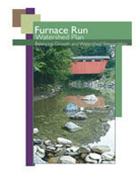
FURNACE RUN BALANCED GROWTH WATERSHED PLAN COMPLETED
Beginning in 2009, the communities of Richfield Village, Richfield Township, Brecksville, Broadview Heights, Bath and Boston Townships and Cuyahoga Falls joined Cuyahoga River Community Planning and representatives of Cuyahoga Valley National Park and Metro Parks Serving Summit County to form the Furnace Run Watershed Planning Partnership. The goal was to prioritize areas of the watershed characterized for conservation, development and agricultural uses.
The product of this two-year process is the Furnace Run Balanced Growth Watershed Plan, designed to balance the need to conserve ecological functions of the watershed with the need for economic growth to sustain communities. The process included:
• Mapping the critical watershed features that describe the character and function of the watershed
• Identifying local criteria for prioritizing Priority Conservation Areas, Priority Development Areas and Priority Agricultural Areas
• Identifying land areas for each category
Furnace Run originates in Brecksville, Broadview Heights and Richfield in northern Summit and southern Cuyahoga counties in northeast Ohio. It flows approximately 10.4 miles southeast through Bath and Boston townships to meet the Cuyahoga River at river mile (RM) 33.08. It drains approximately 35 square miles of predominately suburban lands. A 2001 satellite land cover analysis determined that approximately 14 % of the watershed is considered urbanized with generally impervious surfaces. The remaining 86 % of the watershed is comprised primarily of wooded (47%), grass/agricultural (34%) shrub/scrub (7%) cover (Cuyahoga River RAP, 2004).
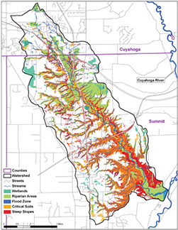
Furnace Run Metro Park, operated by Metroparks Serving Summit County, is located within the Furnace Run watershed. It currently consists of seven tracts of land totaling approximately 870 acres in Richfield. The tracts are fragmented east-west by Interstate 77, State Route (SR) 21, and Brecksville Road, and north-south by Brush Road and State Route 303; however, two of the southernmost tracts, approximating 43 acres along Wheatley Road, are disjunct from the remainder of the park and ecologically separated by Interstate 271. The Cuyahoga Valley National Park (CVNP) also has property with in the Furnace Run Watershed. Furnace Run Metro Park is contiguous with Cuyahoga Valley National Park, which contains 30,000 acres of wetland and forest along the Cuyahoga River from Akron to Cleveland.
CHARACTERISTICS
Drainage:
Drains approximately 20.34 square miles
Length: Furnace Run is approximately 10.4 miles long.
Gradient:
Changes in elevation from 1252ft to 691ft, dropping 561 feet on its way to its confluence with the Cuyahoga River at River Mile 33.08 in Boston Township. Its average fall is 54 feet per mile.
Land Cover:
Land Cover 2001:
Urbanized Generally Impervious- 14.11%
Barren & Misc.- 1.84%
Grass & Agriculture- 34.42%
Shrub & Scrub Cover- 6.68%
Wooded- 47.13%
Streams & Surface Water- .24
ENVIRONMENTAL CONDITIONS
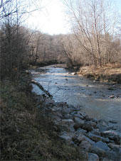
Furnace Run is one of healthiest, intact streams that flow into the Cuyahoga River. Previous work in Furnace Run (1991-1996) indicated that this watershed is in full attainment of biological and water quality standards- which means Furnace Run is meeting Ohio EPA standards. Some sites within Furnace Run exceeded Ohio EPA standards and were noted as “Exceptional Warm Water Habitat (EWH)”.
However, a study conducted in 2003 by Metroparks Serving Summit County found that Rock Creek, a tributary to Furnace Run, was in non-attainment. Although the stream habitat was in good enough condition to support higher level aquatic life communities and meet Ohio EPA standards, it was not in attainment. This was attributed to upstream runoff from slag leachate, during and immediately following, construction of the Interstate 80 interchange near this area in 2000-2001, along with some channelized stream conditions immediately downstream.
AQUATIC LIFE AND HABITAT
The results of the aquatic life and habitat evaluations indicate that this watershed is in PARTIAL attainment. Although the fish community in both Rock Creek and Furnace Run are meeting EPA criteria, the aquatic insect community is showing signs of impairment. PARTIAL attainment in the Rock Creek tributary to Furnace Run is due to historical impacts from upstream pollution sources. However, aquatic life has improved in Rock Creek from 2003 to 2006. This indicates that this small tributary is improving or adjusting to the impacts from the slag leachate discharge from upstream sources, although water chemistry results indicate that these impacts are not diminishing with time.
The stream restoration area in the Furnace Run mainstem (RM 7.8) was completed in 1999. This project consisted of returning Furnace Run to its original watercourse after previously being diverted to Brushwood Lake. Restoration of this stream segment consisted of utilizing soil bioengineering techniques to improve riparian habitat. The 2003 survey conducted by Metroparks serving Summit County found this area to be in PARTIAL attainment with Ohio WQS for aquatic life, while the 2006 survey found the area to be in FULL attainment. This indicates that the restoration project has been a success in this stream segment.
WATERSHED HYDROLOGY
Significant bank erosion is occurring in lower Furnace Run based on visual observations of banks at sampling sites along with excessive amounts of silts/clays covering the stream bottom. The stream bottom at RM 4.8 was covered with gray silts which clearly appeared to have eroded from the stream banks. This can be attributed to recent heavy rains and runoff from new and old development that lack proper stormwater control.
WATER QUALITY Furnace Run has good water quality with recent data showing no exceedences of standards. On the other hand, Rock Creek’s water quality is showing signs of stress. Samples indicate the stream is receiving polluted runoff, as evidenced in elevated dissolved solids. This decrease in water quality is most likely as result from the slag leachate runoff from the Ohio turnpike interchange construction upstream.
Cuyahoga River Restoration
c/o Cuyahoga River Community Planning
1299 Superior Ave. E • Cleveland, OH 44114
216-241-2414 • info@cuyahogariver.org