(Cuyahoga River Community Planning)
The Cuyahoga River
and its Watershed
A River with a Past...
Crooked River, Burning River, this river with many names is, by any name, a river with a past. Many pasts, in fact. There was the 11,000BC river that formed from the last glacial retreat. Then, and for most of its life, there was the river that grew oak and hickory forests that sustained the host of American Indian tribes who fished and hunted throughout the 100-mile fertile valley and 800 square miles of hilly watershed. There was the river that drew trappers, traders, adventurers, and eventually in the early 1700s, white settlers.
Clevelanders may mark the history of their city's beginning in 1796, when Moses Cleaveland came to survey the Western Reserve and left the first settlers where the river meets Lake Erie. But life along the southern turn of the river had been going on long before that.
By the turn into the 18th century, the Cuyahoga River had become the official western boundary of the new United States of America. Some surveyers had stayed when Cleaveland went back east, and new families and townships grew along the river and throughout the region. Flowing water powered mills and filled the new Ohio & Erie Canal which would provide consistent passage for cargo between Lake Erie and the Ohio River.
Throughout the 1800s, with its access to Lake shipping, railroads, and the canal, the last five miles of the Cuyahoga – the shipping channel – became lined with steel mills, oil refineries, and other manufacturing facilities that helped make Cleveland an industrial giant and the Cuyahoga a polluted sewer. The late 1860s saw the first fire on the river, but hardly the last.
The fire of 1969 was neither the first nor the worst, and it wasn't the only river that caught on fire as industrial pollution degraded major waterways. But it was the spark that ignited the nation’s clean water movement and led to passage of the Clean Water Act. The nation had begun to pay attention to environmental degradation. Time magazine's August 1, 1969 issue provided a turning point. The issue contained a story about America's polluted rivers and highlighted the fire on the Cuyahoga. It made a difference. The Clean Water Act was signed shortly thereafter, the Environmental Protection Agency was created, and in 1972 the Great Lakes Water Quality Agreement committed the U.S. and Canada to restoring and protecting the lakes that hold more than 80% of the country's fresh water.
In the following years, the lower Cuyahoga, from Akron to Lake Erie, was one of dozens of waterways identified as Areas of Concern, the most polluted contributors to the degradation of the lakes. Ohio EPA and a committee of local stakeholders were required to develop a Remedial Action Plan (RAP) to identify and remedy the problems.
As pollution regulations were put in place, and industrial use waned, the river slowly began to recover. The creation of the Cuyahoga Valley National Recreation Area, later to become a National Park, put 22 miles of the river between Akron and Cleveland under the protection of the Department of the Interior. Stewardship and protection of the river and many of its tributaries by park systems and local watershed groups have brought people and institutions together to work on bringing the waters back to life.
Meanwhile, upstream, the first fifty miles of the Cuyahoga from its headwaters in Geauga County to Akron have been protected and healthy, as they are the source of that city's drinking water.
... a Present...
Through effective partnerships, shared responsibility, and the recognition that the Cuyahoga is an asset to the community, the river continues to serve as the center of an active maritime industry, a growing recreational attraction, the home of a national park, the link that connects the cities of Cleveland and Akron, and the hub of Cleveland’s urban revitalization.
The river lives. Fish populations, health, and variety of species have increased hundreds-fold, recreational activity has grown, and new riverside residential and commercial development speaks to the belief that the river is a good place to live, a resource to protect, and a destination to invest in.
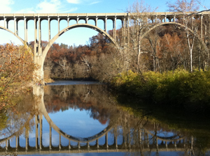
Upriver, dams in Kent, Munroe Falls, and Cuyahoga Falls have been removed or bypassed, allowing free passage for fish as well as paddlers between Lake Rockwell and the Gorge Dam in Akron.
In the ship channel, dozens of school rowing crews ply the waters daily and the Cleveland Rowing Foundation hosts national rowing regattas annually. Next door, the Cleveland Metroparks' Rivergate Reservation hosts a new riverside restaurant, offers organized kayak tours, and is preparing to launch a new ferry service. A new section of the Ohio & Erie Canal Towpath Trail runs alongside new fish habitat areas, where herons come to lunch just below Tower City. Near the mouth of the river, in "the flats", workers at the new Flats East Bank offices and hotel and restaurant visitors watch a new mixed use development rise. West Bank attractions draw crowds year-round.
At the same time, bacteria coming from overflows of combined sanitary and stormwater sewer systems during and after heavy rains continue to make the river from Akron to the Lake unhealthy for swimming. Dams at Akron and the national park prevent fish from using the whole of the river for migration and reproduction. Fish habitat has been lost as streams are filled and their banks denuded of forest and vegetation. Nutrients from agriculture upriver and excessive fertilization of land throughout the watershed run off into the tributaries and to the lake. Stormwater overwhelms the built infrastructure designed to carry it away as land is paved and wetlands that would store it are filled in for development.
...and a Future.
With dozens of partners – businesses, park systems, government agencies, nonprofits – and hundreds of committed individuals – restoration will continue. With the plan in place and restoration projects underway throughout the watershed, the future is bright.
Federal funding from the Great Lakes Restoration Initiative has allowed us to do more.
Key actions that we and are partners will continue to focus on include:
• removal of dams to allow fish and recreational users to pass;
• remediation of sewer overflows;
• restoration of aquatic habitat in the ship channel and tributaries;
• restoration of streams and buffer zones;
• removal, reduction and management of sediment both toxic and clean;
• nutrient reduction; and
• education and outreach for watershed stewardship
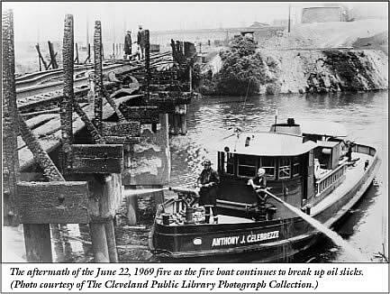
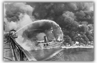
The image most people connect with the 1969 fire is not actually a photo of that fire. That fire was relatively small and extinguished before news photographers could get to the scene. The photo below is of the aftermath of that fire. The one below it, the one used most often, is really a photo of the 1952 fire.
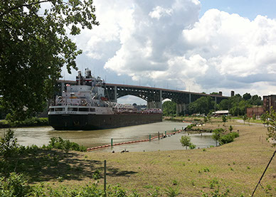
The ship channel today, where nature lives alongside commerce.
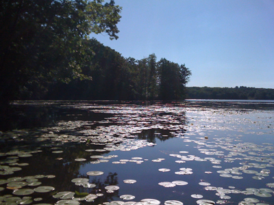
The East Branch of the Cuyahoga in Geauga County, where the river begins.
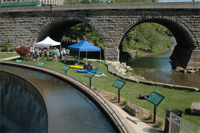
The Cuyahoga flows freely now through the City of Kent.
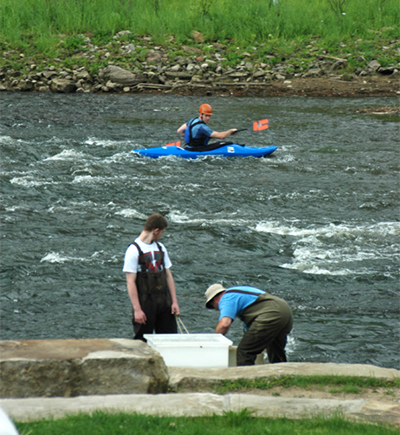
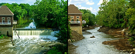
Removal of the Munroe Falls dam has opened more river for recreation (and fishing.)
Removal of two dams in Cuyahoga Falls brings us closer to a free Cuyahoga. (Before-and-after photos courtesy of Eilert Ofstead.)
Cuyahoga River Restoration
c/o Cuyahoga River Community Planning
1299 Superior Ave. E • Cleveland, OH 44114
216-241-2414 • info@cuyahogariver.org